Title page Content Tables Figures Acronyms Introduction Indicators Crop Types Aggregation Levels Use Cases Project Partners FAQs Publications Information Desk
|
Aggregation Levels Beta Version (January 2017) | ||
|
CAWa/WP3 - Univ. of Wuerzburg (RP for glossary Dr. S. Schönbrodt-Stitt) |
Created: 10.01.2017 12:51:24 |
Updated: 20.01.2017 12:19:11 |
List and Explanation of Aggregation Levels as used in WUEMoCA
(hierarchical order)
- Province - District - BISA - ISA - WUA - Channel command area -
and
- Regular raster -
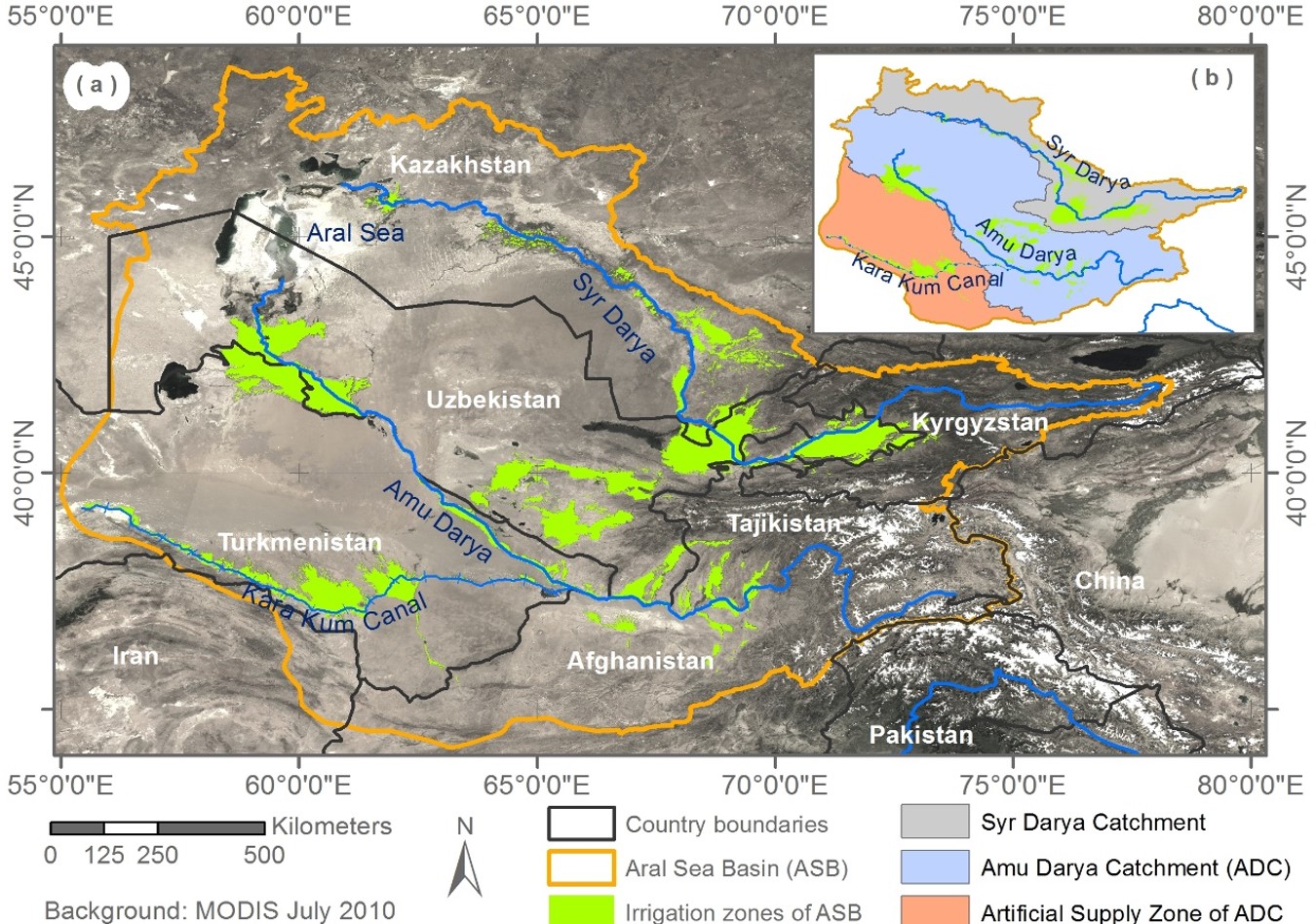
Table 2 (c.f., 'Indicators implemented in WUEMoCA') gives information what crop type(s) and indictor(s) implemented can be selected at the above aggregation levels. Definitons of aggregation levels as implemented in the online information tool WUEMoCA are given below. Information on the availability of those aggregation levels implemented in WUEMoCa for the different countries contributing to the ASB is given in Table 3. Information on the spatial distribution of the irrigation zones within the maximaum irrigation extent shared by the Amu Darya and Syr Darya river catchments and the artificial water supply zone of the Kara Kum Canal in the ASB is given in Figure 1.
Figure 1. (a) MODIS MOD09 1 km map showing the Aral Sea BAsin, the two main receiving rivers Amu Darya and Syr Darya, and the Kara Kum Canal as well as the irrigation zones within the maximum irrigation extent (green clored; (b) overview on the Amu Darya and Syr Darya river catchments and the artificial water supply zone introduced by the Kara Kum Canal. Source: Conrad et al. (2016).
(oblast, oblys, viloyat, welaýat, viloyat)
Adminstrative and territorial devision (unit) in the countries of Afghanistan, Kazakhstan, Kyrgyzstan, Tajikistan, Turkmenistan, and Uzbekistan.
(rayon)
District Type of administrative devision that is mostly managed by local government. In Afghanistan, a district (Persian/Pashto: ولسوالۍ / Wuleswali) is a subdivision of a province. In Kazahkstan, Kyrgyzstan, Tajikistan, Turkmenistan, and Uzbekistan, districts (rayons) are administrative and municipal devision of the federal subjects and administrative divisions of larger city (i.e, city districts such as Tashkent in Uzbekistan).
(BUIS)
BISA Basin irrigation systems authority
(UIS)
ISA Irrigation systems authority
WUA Water user's association
Channel command area
Regular raster
Table 3. Availability of aggregation levels implemented in WUEmoCA for the different countries and pilot areas contributing to the Aral Sea Basin. Explanation: ● = available, ○ = not available.
| Area of Interest | Aggregation levels | ||||||
|
Aral Sea Basin |
● |
● |
○ |
○ |
○ |
○ |
● |
|
Afghanistan |
● |
● |
○ |
○ |
○ |
○ |
● |
|
Kazahkstan |
● |
● |
○ |
○ |
○ |
○ |
● |
|
Kyrgyzstan |
● |
● |
○ |
○ |
○ |
○ |
● |
|
Tajikistan |
● |
● |
○ |
○ |
○ |
○ |
● |
|
Turkmenistan |
● |
● |
○ |
○ |
○ |
○ |
● |
|
Uzbekistan |
● |
● |
● |
● |
○ |
○ |
● |
|
Fergana province (Pilot area) |
● |
● |
● |
● |
● |
● |
● |
|
Khorezm province (Pilot area) |
● |
● |
● |
● |
● |
○ |
● |
|
Dargom ISA (Pilot area) |
○ |
○ |
○ |
● |
○ |
○ |
○ |
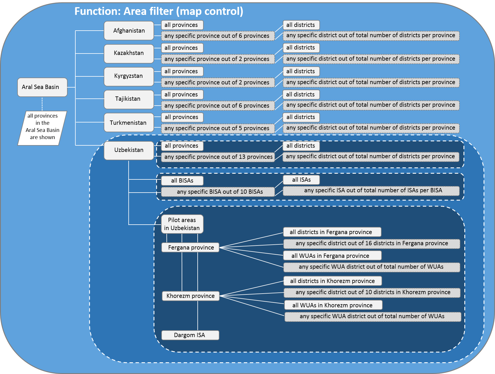
Figure XXX. Area filter (map control).